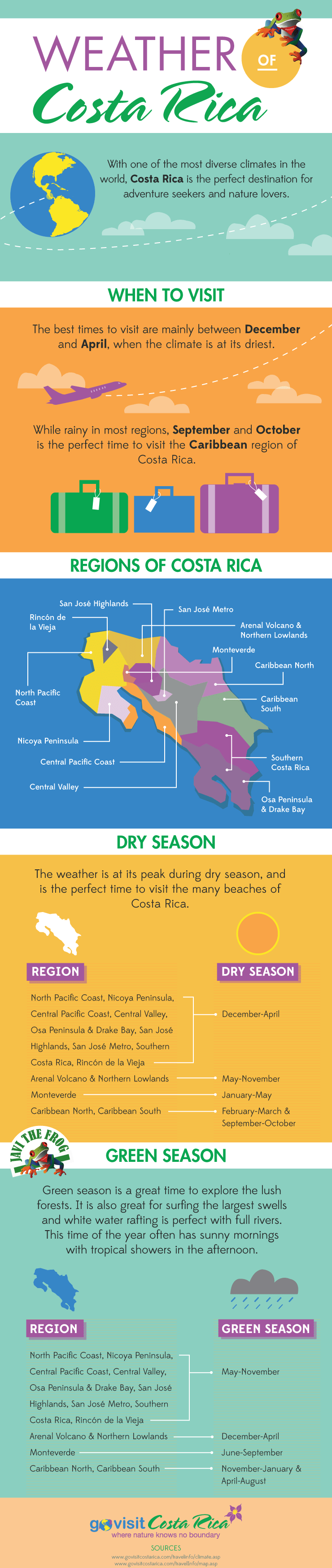
Experience the Diverse Tropical Climate of Costa Rica
Costa Rica is a top tropical travel destination for millions of travelers each year and Costa Rica’s exceptional weather is one of the main reasons so many tourists flock from all over the world to experience it for themselves.
The country is made up of many different climate zones, creating unique microclimates within the country. The topography, including everything from mountains and volcanoes to beaches and valleys, contributes to the varying weather patterns, making it unlike almost any other country in the world.
Because of the mountainous terrain across the land, proximity to the equator and prevalent sea breezes which all contribute to temperatures, rainfall totals and more, Costa Rica experiences many types of different weather patterns based on the area or region of the country. With such variance in elevation, proximity to the Pacific Ocean to the west and Caribbean Sea to the east, on any given day, it could be hot and dry on the coast but rainy and cool inland.
Costa Rica is classified as a tropical country with no true winter season due to its proximity to the equator. It is more or less divided into two seasons, a dry season, often referred to as high season, and a rainy season, often referred to as green season.
Overall, the country stays pretty warm year-round offering around twelve hours of sunlight to its residents and visitors every day throughout the year.
Having so many different microclimates and weather patterns in one country can be confusing and a lot to figure out when you’re trying to plan the perfect Costa Rican vacation.
This weather page was designed to help you understand all you need to know to choose the best time to visit Costa Rica.
Beautiful view of Playa Herradura coastline
What is the Landscape Like and How Does it Contribute to Costa Rica’s Climate?
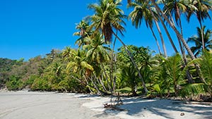
About a third of Costa Rica's land is designated for the welfare of their wildlife, so you can expect to see plenty of lush rainforests and jungles extending from the highlands all the way to many of the country's world-class beaches.
The shorelines on both the east and west coasts of Costa Rica are breathtaking and have been largely undisturbed as it is unlawful to touch the first fifty meters inland from the highest tide in Costa Rica. This means that when you walk onto most beaches, there is no construction in the way, and you can expect to view blue waters, warm sands and nearby lush forests!
Even though the law did not come into effect to restrict development in most areas of the Guanacaste region and Puntarenas, numerous beaches appear to be undeveloped. The country's center is densely forested, with mountains, valleys, and rivers, and the weather can quickly change from hot and humid in popular destinations such as Jacó to chilly enough to wear a sweater in the El Cerro de la Muerte's forest.
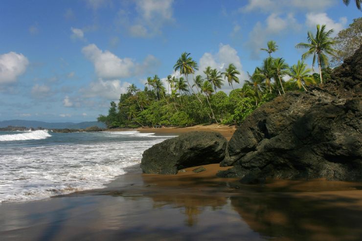
The south Osa Peninsula has evergreen rainforests, while Guanacaste has deciduous woods that turn completely brown during the dry season. High waves and currents can be found on the Pacific side while snorkeling seas can be found on the Caribbean side.
It is this varying landscape throughout the country that directly contributes to the Costa Rica weather forecast being so varied by location throughout the country.
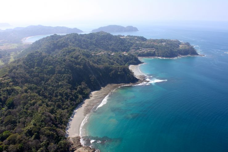
Sunset at Playa Mansita in front of the JW Marriott Guanacaste
Average Temperatures in Costa Rica
Due to the number of microclimates in Costa Rica, it can be hard to 'average' the temperatures for the entirety of the country. However, each climate zone has its temperature averages, with minimal differences no matter the time of year of your visit.
The temperature difference between January and July for example, is negligible. The average annual temperature in Costa Rica is 70° to 81° Fahrenheit (12° to 27° Celsius) with the coast and inland lowlands being hotter than the mountains.
In what's referred to as the highlands, the temperature averages 55° Fahrenheit (13° Celsius), while at sea level, also known as the lowlands, the temperature averages around 79° Fahrenheit (26° Celsius).
Costa Rica is located between both the Caribbean Sea and the Pacific Ocean. Elevation has an impact on the climate, and the average temperatures, of many regions.
The weather in Tortuguero is hot, humid, and rainy for most of the year due to its proximity to the Caribbean Sea. At the same time, the weather in San José’s central valley has a beautiful breeze and averages about 72° Fahrenheit (22° Celsius).
As you can see, Costa Rica’s capital, San José Costa Rica, and the central valley area has its own microclimate, that controls not only it’s temperatures, but it’s rainfall, humidity and more!

Happy while white water tubing
What are the Hottest Months of the Year in Costa Rica?
Average temperatures across Costa Rica don’t vary greatly based on time of year, with a relatively minimal difference between January and July.
The dry season in Costa Rica ends in April. The hottest months of the year in Costa Rica are February to April, with the highest temperature for a given day often landing in the months of March or April each year.
During these warmer months, most of the Pacific Coast and in the Central Mountains are drenched with plenty of sunshine. April brings sunshine in the mornings and gentle rain to this lush region in the afternoons. Rain starts to fall in the Central Pacific (Manuel Antonio, Dominical, and Uvita) at the end of April which controls the temperatures for those areas.

Saying "Hi" from the Monteverde Cloud Forest
How Cold Does It Get in Costa Rica?
Although Costa Rica is often regarded as a warm country, there are a few places where it may get rather chilly or by Costa Rica standards, a little cold!
The months of September through November are generally the coldest months that the country sees, however this does vary region to region.
Costa Rica's harshest regions are in the mountains, where overnight temperatures routinely drop below 50° Fahrenheit (10° Celsius).
Costa Rica has had temperatures as low as 16° Fahrenheit (-8.9° Celsius). This temperature record was established on the highest mountain in the country, Cerro Chirripó, which of course, is expected due to the terrain. This is the coldest it has ever gotten in recorded history in Costa Rica, but typically you don't see this temperature plunge at sea level.
With average temperatures ranging from 61° Fahrenheit (16.1° Celsius) to 85.1° Fahrenheit (29.5°Celsius), September is the coldest month of the year but again it varies in the different regions of Costa Rica. Even though September is cooler than the other months, the ocean is still warm at 82° Fahrenheit (27.8° Celsius), making it an excellent time to visit the beach.
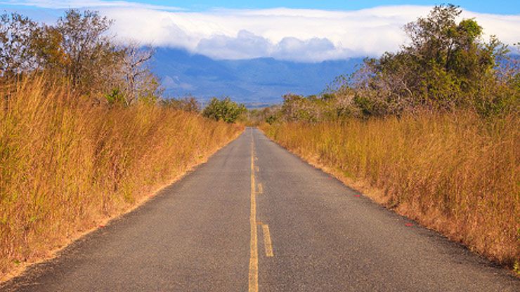
Driving to Guanacaste National Park
Where Does it Get the Hottest in Costa Rica?
If you’re searching for the highest temperature you can find in Costa Rica, head to Costa Rica's northern Pacific coast and take in the area's warm climate. The Gold Coast, as it is known, receives the least amount of rainfall and offers visitors some of the sunniest days anywhere in the country.
However, you'll find the hottest weather a touch further south on the coast, especially on the Southeast and Northwest sides of the Nicoya peninsula. These areas see no more than 40 to 60 inches of rain per year and offer nearly year-round hot weather where it can exceed 100° Fahrenheit (37.8° Celsius).
It typically averages 72° to 98° Fahrenheit (22.2° to 36.7° Celsius), hardly ever dropping below 72° at night or rising above 98° degrees during the day!
If you enjoy milder weather, the lowlands and coastal sections of Costa Rica have an average temperature of 79° Fahrenheit (26.1° Celsius), perfect for your next Costa Rican vacation!
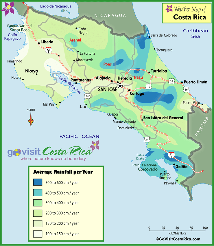
Rainfall in Costa Rica
The amount of rain that falls in Costa Rica varies quite a bit, from region to region and year to year.
For much of Costa Rica, heavy rain, primarily in the afternoons, and scattered showers at any time are likely from May to November, with September and October seeing the most rainfall.
In contrast, December through April often present relatively little rain and some areas may not get any rainfall at all!
The country receives roughly 100 inches of rain each year on average, with certain areas receiving up to 25 feet or 300 inches of rain per calendar year in mountainous locations.
Like many parts of the country, Costa Rica's Caribbean Coast has its own distinct microclimate. When visiting the area, you will see that it rains frequently, and there is no true rainy season.
Costa Rica is made up of many different weather systems and microclimates. Knowing the months in the area you are visiting that are in high season (dry season) or green season (rainy season) will help you navigate the Costa Rica climate, understand Costa Rica weather by month, by area and help you decide the best time to visit Costa Rica!
For an easy visual representation of yearly rainfall throughout the regions and microclimates of Costa Rica, be sure to check out the Costa Rica Rainfall Map. For a month-by-month chart of the seasons in Costa Rica, utilize the Costa Rica Weather Chart above.

Driving to Monteverde with Eurpocar
What are the Roads like During the Rainy Season in Costa Rica?
Costa Rica is a country of varying elevations, from mountain highlands to valleys and beach lowlands. Roads are frequently cut through rugged mountains with steep slopes on either side. Landslides can occur when it rains heavily.
The majority of roads in Costa Rica however are modest, with the potential for a bit of dirt or rocks falling into the road and obstructing a lane primarily during the rainy season. In most cases, a backhoe can clean them up in a matter of hours.
On the other hand, more significant rain events can cause massive pieces of ground to slip and cause issues. Use caution when driving during the rainy season, try to use the roads primarily during the daylight hours and leave ample time to arrive at your destination.
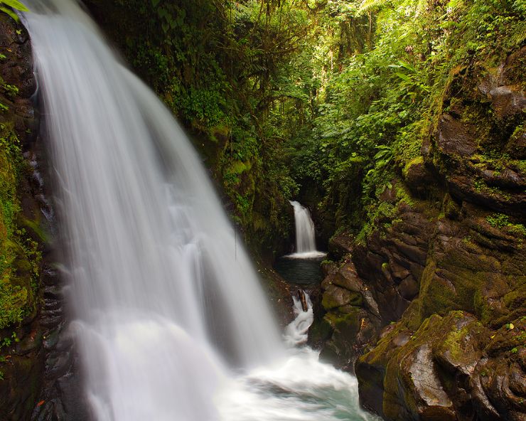
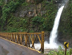
Beautiful La Paz Waterfall
Why is the Rainy Season Often Called the Green Season in Costa Rica?
For most of Costa Rica, the rainy season isn't as severe as one may think. This is precisely why, nowadays, many people refer to this time of year as the green season rather than the wet season.
This is a time that is vital to the Costa Rica climate and the reason the rainy season is called the green season, because the jungles, forest and flowers throughout the country use the rainfall to flourish and turn ‘green’!
The rainy season officially begins for most of the country in May and ends in November. Despite some severe daily rainstorms in May and over the summer months, many areas experience the most rain in October. Long rainy days are conceivable during this time, but seldom for numerous days in a row.
A typical rainy season day in Costa Rica begins brightly and ends with the possibility of a brief, but sometimes intense, rain shower beginning in the mid-afternoon hours.

Heavy rain in the vegetation of Turrialba
What is the Average Yearly Rainfall in Costa Rica?
Costa Rica's average annual rainfall across the entire country is 100 inches. With microclimates throughout, the more mountainous rainforest areas can receive 3 times as much or up to 25 feet (300 inches)!
Costa Rica’s average yearly rainfall is not evenly spread out with most of the rain happening in the green season, or the rainy season.
Central America as a whole experiences similar weather conditions. Warm water currents influence weather patterns in Costa Rica and worldwide in the Pacific Ocean.
El Niño is the name given to this phenomenon. La Niña is a term used to describe the weather condition where cold water and meteorological conditions change the weather, all affecting the average yearly rainfall in the country.
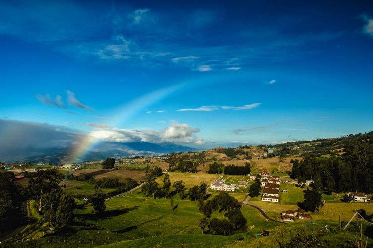
Rainbow over Sanatorio Duran looking at Irazú Volcano
Costa Rica Weather, Seasons and Regional Climate Zones
When it comes to Costa Rica’s climate and the Costa Rica weather forecast, the proximity of the Pacific Ocean and the Caribbean Sea plus the mountain ranges that separate these two bodies of water help make Costa Rica the tropical paradise enjoyed by so many visitors each year.
You'll experience a completely different microclimate whether you travel from one side of Costa Rica to the other or the coast to the mountains. Higher elevations are generally cooler and have more rain while lower can be mild, sunny and perfect for a Costa Rican vacation!
Visiting in high season or green season will change the weather conditions and weather forecast as well as the climate zone or area you plan to explore.
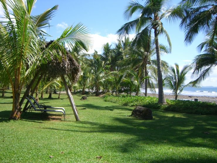
Amazing Islita Beach
What are Costa Rica's Weather Seasons?
The dry season "summer" (verano in Spanish) from December to April and the rainy season "winter" (invierno in Spanish) from May to November are Costa Rica's two distinct weather seasons.
The beach locations of Guanacaste and Nicoya in Costa Rica's northwest region are best described as "dry" and "rainy." The majority of the Pacific coast and much of the central mountains follow a similar trend, though with slightly higher precipitation.
For a region by region breakdown, check out the Costa Rica Weather Chart above.
As you can see, the chart takes Costa Rica weather by region and considers Costa Rica weather by month, sharing which season, dry or rainy, you should expect based on when you are looking to visit. Knowing the season helps you understand weather averages, weather conditions, and the likely weather forecast for your trip.
With two distinct seasons that affect Costa Rica’s weather, knowing when an area is in green season or high season is important to know as you plan your trip. For example, the North Pacific Coast has its high season from December to April and green season between May and November.
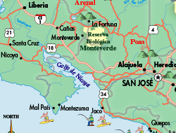
On the other hand, Monteverde has a shorter high season from January to May, while the green season lasts from June to September, with November and December as the windy months.
What is the Weather Like in the Central Valley of Costa Rica?
The Central Valley's climate, home to the capital city of San José and the SJO International Airport, is believed to be one of the most consistent and pleasant in the world. Temperatures are usually in the upper 70's or low 80's Fahrenheit during the day (around 24° to 28° Celsius).
The nights are cooler, with temperatures reaching the mid 60's Fahrenheit (approximately 18° Celsius). With cool temperature and extra humidity after the sun goes down, we recommend bringing a light sweater with you so you are comfortable.
What are the Regional Climate Zones in Costa Rica?
There are 13 regional climate zones in Costa Rica. To see when each is in the high season (dry season) or green season (rainy season), checkout the Costa Rica Weather Chart and for rainfall totals, see the Costa Rica Rainfall Map. The Weather of Costa Rica infographic below also provides a nice visual of Costa Rica’s regions and corresponding weather.
Each region has a unique microclimate that affects its weather.
Read on to learn more about some of the climate zones of Costa Rica.
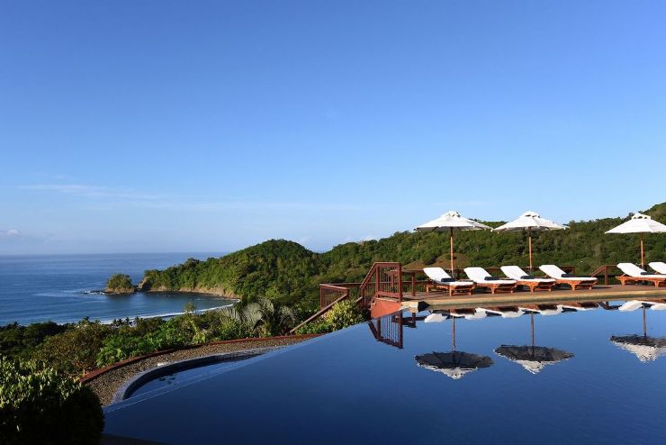
Hotel Punta Islita pool overlooking the Pacific Ocean
The Guanacaste Province on the northwestern Pacific coast of Costa Rica, experiences its driest month of the year in December to March, with only 4% of the yearly precipitation falling during this time. April is a transition month, with the rainy season beginning in May and lasting until August (50% of annual rainfall).
June is the wettest month, with the Pacific veranillo, the area’s sunny break, arriving in July and August when the trade winds pick up. The second rainy season lasts from September through November before giving way again to the dry season.
Awesome beach rock formations in Corcovado National Park
The Osa Peninsula and the Central Pacific Coast from Puntarenas to Golfo Dulce makeup this incredible area of Costa Rica. With an average annual precipitation of 138 inches annually, rainfall is higher in the valleys and the south of the region.
The average maximum temperature is 89° Fahrenheit (31° Celsius), while the average minimum temperature is 73° Fahrenheit (22.7° Celsius).
From January to March, the dry season is in effect. April, still mostly dry, is a month of transition, leading up to the rainy season, which begins in early May and lasts until November. December is a month of transformation and the start of the high season or dry season in these regions.
Do know as you travel south, the total amount of precipitation increases.
Beautiful view from Cerro de la Muerte
The Central Volcanic Range, the Cerros de Escazu, Tablazo, Cedral, and the Candelaria Ridge to the north, the Monte del Aguacate to the west, and the Cordillera de Talamanca to the east, all border this region in the country's center. San José, Heredia, Alajuela, and Cartago are among the country's major cities and located in these regions.
The lower sections of the Western Central Valley (Atenas, Turrúcares, La Garita, and La Guácima) have a dry climate with a strong Pacific influence. The Southern Costa Rica region stretches all the way to the southern border of the country shared with Panama with a tropical climate well-known to Costa Rica.
Its intermediate regions (San José, Heredia, and Cartago) have a temperate climate, whereas the upper parts, typical of the hilly area and San José Highlands, are rainy and cooler.
There are approximately 148 rainy days in the year here but with moderate temperatures year-round, many believe the Central Valley and San José has some of the best weather in all of Costa Rica!

Arenal Volcano Smoking
The Río San Juan and Nicaragua in the north, the Central Volcanic Range in the south, and the Cordillera de Guanacaste and Cordillera Tilarán in the west border this region of Costa Rica. The Río Chirripó is widely regarded as the region's eastern border with the Caribbean.
It is located in the Caribbean precipitation region, with a green season from December through April and the dry season from May through November.
Due to its steep relief and the presence of vast plains, as well as the presence of Lake Nicaragua to the northwest, it is a region with diverse rainfall, as climatic components and topographical variables combine.
Home to the Arenal Volcano, one of the most popular places to visit in Costa Rica, make sure to check the weather forecast before you arrive to make the most of your trip.

Beautiful suspension bridge in Monteverde
Monteverde is a fantastic part of Costa Rica and well worth considering a visit for your next trip to Costa Rica!
With its own microclimate, the region experiences the rainy season from June through September each summer and is relatively dry from January through May with October, November and December being transition months in the region.
Palms over the ocean on Cahuita beach
The east coast of Costa Rica spans the entire Caribbean coast from Barra del Colorado to Puerto Viejo and the Río Sixaola in the south, making up the east and northeast of the country. The Cordillera de Talamanca runs through it on the south, while the Río Chirripó runs on the west. The province of Limón and the eastern half of Cartago - the Turrialba Canton - makeup this region.
The monthly and annual precipitation figures show that the northern and southern regions have different microclimates. The yearly precipitation gradient diminishes from north to south, with 135 to 175 inches in the north to 100 to 120 inches in the south.
Green season is November to January and April to August while a dryer weather forecast is expected each year during the region's high seasons in February, March, September and October.
Costa Rica Weather by Location
The weather in Costa Rica is tropical and mild with two separate seasons and many microclimates. The part of the country you visit matters when it comes to Costa Rica weather.

Statue at the back of Art Museum in La Sabana Park
What Area of Costa Rica Has the Best Weather?
The best weather in the country is said to be in the central valley of San José.
You will usually find a breeze and the temperatures averaging about 72° Fahrenheit (22° Celsius). This is very similar to the weather in San Diego, CA where the average temperature ranges from the high 60's to the low 70's Fahrenheit.
Why is the Weather in Costa Rica so Varied and What Should You Expect?
The weather in Costa Rica can be unpredictable, so it can rain at any time, no matter where you are located. There are, however, annual patterns worth understanding. This knowledge will help you plan your journey to increase your chances of experiencing the most incredible weather.
The weather in Costa Rica is so varied due to elevation, distance from the coast, seasonal patterns and forest cover to name a few and are all used to divide the country into climate zones and microclimate pockets.
Coastal mangroves, tropical rainforest, near-desert conditions, and cloud forests are among the terrain options to name a few. Each of these pockets, which can be as near as a few kilometers apart, can produce varied and distinct weather patterns.
Seasonal patterns, dry or rainy, affect Costa Rican weather as well, though not to the extent that they do in areas like the United States and Canada.
You can expect the Pacific slope and coastal areas to get the most excellent weather from December through April. Around May, the South Pacific begins to experience daily showers, which gradually intensify into heavier rainfall as the season advances. This area experiences severe rains around the end of August and early September.
Rains do not start to consistently fall further up the Pacific coast, in places like the Guanacaste beaches, until approximately mid-July. The heavy rains usually only last until September and October.
Unlike the Pacific coast, September and October are the finest months to visit Costa Rica's Caribbean coast. It is usually pleasant on that side during February, March, April, May, and August, and other months can be pretty rainy.
The one thing to know about the Caribbean coast of Costa Rica is that the weather is notorious for being fickle.
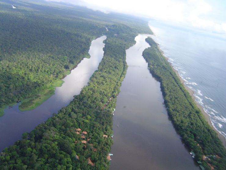
Tortuguero Canal
What Side of Costa Rica Has the Best Weather?
It’s not easy to choose between the two coasts when considering which side has the best weather. Both sides of Costa Rica are beautiful, but the Central and Southern Pacific Coasts are our favorites!
The Pacific Coast’s dry season spans from December to April, corresponding with the snowy winter months in the US, Canada and Europe. Many frequent travelers would say this area has the best weather in Costa Rica.
Locals may argue that the east coast or Caribbean side of Costa Rica has the best weather as it is generally dry in September and October when much of the country is in the middle of their rainy season.
Know Before you Go & Weather Tips for Your Vacation

Beautiful side room view at Pachira Lodge, Tortuguero
Two Different Seasons
Remember that there is a dry season and rainy season in Costa Rica.
Much of the country is dry from December to April and rainy from May to November but check the Costa Rica Weather Chart for the area you are considering visiting before you depart.
Costa Rican Weather of Today
Today's increasingly unpredictable environment can make the weather forecast hard to predict.
Expect sun, rain, and everything in between on both coastlines every day. The good news is Costa Rica is always generally pleasant and warm, and when it rains, it rarely lasts more than a few hours.
Come Prepared
Costa Rica is located along the equator and thus the sun can be extra hot during the heat of the day. Bring sunscreen, a hat, sunglasses, sandals and clothes that won’t be damaged if they get wet.
The Best Climate in the World!
It takes a lot of confidence to boast that you have "The Best Climate in the World." Despite this, the small town of Atenas, Costa Rica, has asserted that it has the best climate in the world!
The phrase can be found on the backs of Atenas buses, on a few billboards, and even on the name of a local restaurant.
Less than an hour from the capital of San José as well as some of the best Pacific Coast beaches, the mountainous valley region boasts long sunny days and yearly temperatures ranging from the mid-60s to high 80s Fahrenheit. It's one of Costa Rica's healthiest climates!
You’ll have to visit yourself to decide if you think Atenas, Costa Rica has the best climate in the world!